
|
It's still early in the storm season across Ireland and as such I don't really expect to see anything too impressive this time of year, however that being said surprises can and do happen, we are at that transition zone between the residue of Winter and the full-on affects of Spring, on one hand we still get cold air set-ups with deep cold pools aloft yet on the other the sun is higher and the affects of solar heating are beginning to influence the clouds, in short, this means Cumulus and Towering Cumulus developing over land away from the warmer oceans which produced convection all Winter, a transition is happening in the form of a subtle shift from sea to land. For the reasons mentioned April is often called 'April showers' and depending on the pattern prevalent at the time we can often end up with days of showers or even a few thunderstorms often with a cold bite that reminds us that Winter is still lingering.
This was the synoptic environment this April, it seemed we had many days of convective showers and sporadic lightning and Easter April 3rd was one such day, as is typical of the time of year we had the classic low instability high shear situation which lowers your expectations but at the same time raises them in some strange alter reality where the possibility of something special could happen. This day we had a widespread cool pool of -30c air however the instability was a meager 100j/kg of CAPE, however high resolution models were showing 300 or more j/kg of CAPE on a classic Wly flow. 0-6km shear however was exceptionally strong. If this had been a high CAPE warm and moist Summer day we would be anticipating tornadoes, however without the deep moisture, low instability, and cooler temperatures one never really knows for sure what will happen. At this time of year thunder is often very sporadic however the prospect of a convective photo opportunity is much higher, such things as gust fronts, anvils and mammatus tend to be more likely in these scenarios which can be very camera friendly and dramatic so I'm always on the look out. I can honestly say with few exceptions that the best mammatus clouds I've ever seen have been associated with these cold air mass set-ups during Spring, late Autumn or Winter and never with the biggest thunderstorm days.
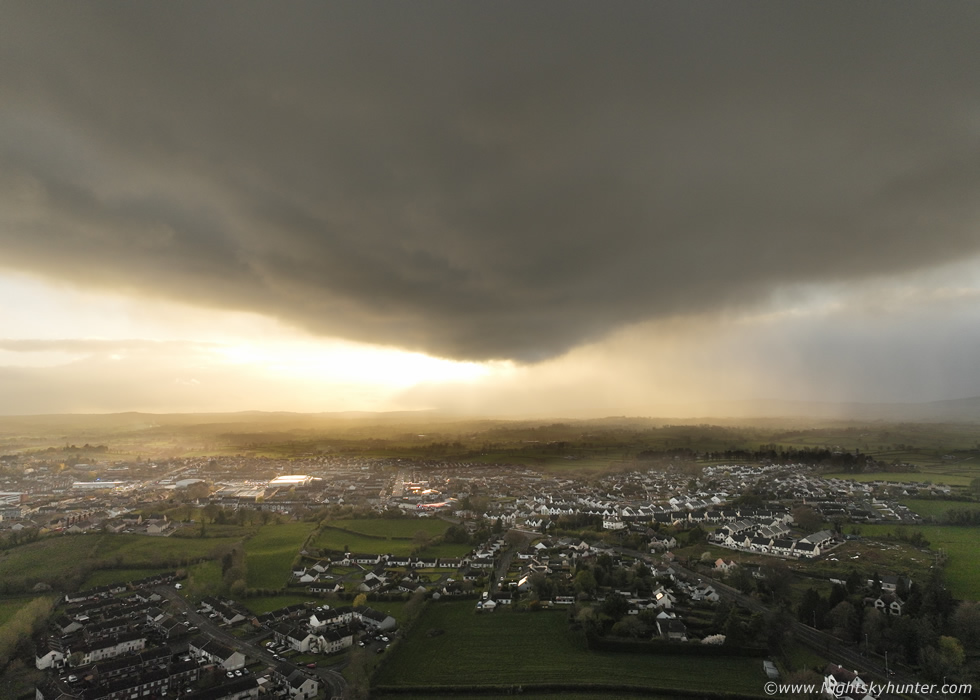
Today was Easter Sunday, I was aware of the forecast and was watching the skies, however we had also planned a nice turkey dinner and Roisin's Mum and Sister where coming to the house for dinner so Roisin was making preparations and we still had a visit to do to the local shop. I noticed a big cell on radar with red core heading towards Cookstown so I was anticipating something. We where at the local filling station when the core arrived, a prolonged intense period of rain then hail stones, cold hard hail blowing sideways across the pumps, whacking cars, bouncing off the ground, making a loud den on the car roof, all accompanied by gusty outflow winds. People in Cookstown street were caught off guard (why do people never look at the sky) with some being forced to run for shelter. The hail turned to wet snow and it was like Winter all over again, then the cell began moving E and sunshine and blue sky began to appear in it's wake, we could see the outline of a white anvil with pouches and I knew some kind of mammatus were forming, so we drove back home and I got the drone out for a look.
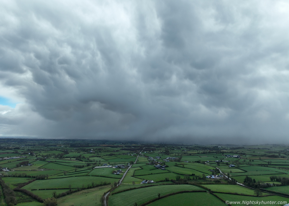 |
Cell immediately east of Cookstown traversing the flat countryside on it's way to the mid section of Lough Neagh. A curtain of hail and snow was falling over the fields and above a weak mammatus display was forming under the wispy anvil.
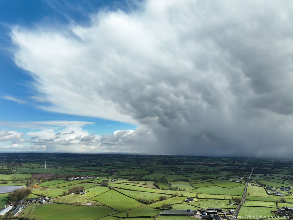 |
The sun came out bringing better contrast and even though the mammatus were not spectacular the overall scene was quite cool with nice colour contrasts and good light so I began taking images and recording footage. This cell was moving fast, which seemed to be the norm this season, it was nice to see the blue skies with the anvil.
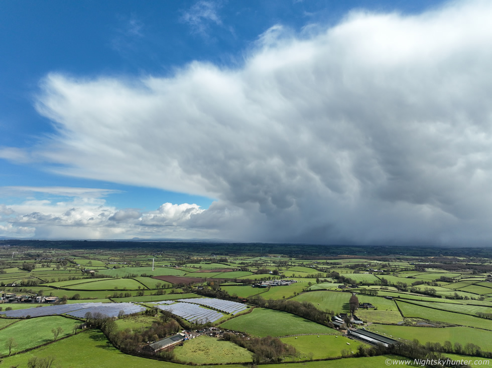 |
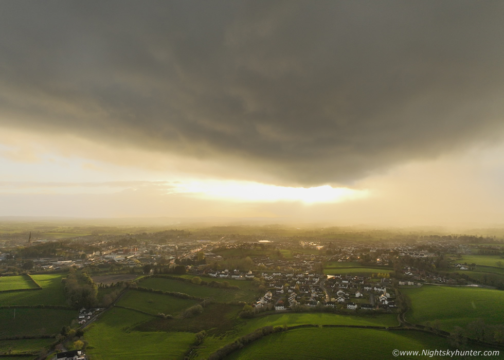
That's the solar panel array below on the way into Cookstown on the left with the cell aloft. The mammatus didn't match the display I captured on the last report however the entire cell was neat enough to be worthy of including on here, especially since we had been under its core earlier and knew it had packed a punch, often in these situations it's the rear of the shower/cell/storm which provides the most photogenic aspect so anytime you are under a heavy shower or storm wait for the rain to stop then step outside and look, if the sun comes out you could witness something stunning, way better than what I'm showing here. An hour later radar showed a thunderstorm close to the east of Cookstown, I couldn't believe it, I never heard the thunder however the cell did pass over and I had the drone up but by that stage the storm was spent and it didn't look impressive, actually the earlier cell above looked much cooler than the actual storm. The timing was great, half an hour later our visitors arrived and we enjoyed a lovely Easter dinner and the sky behaved itself for the rest of the day.
April 8th was another such day, another low CAPE strong shear Wly flow with pockets of 250 CAPE with a lot of showers forecast with a risk of thunder, more so than of late. Ella and I went chasing but decided to make our base at Beaghmore Stone Circles in the Sperrins. Colleen Webb and John Fagan also arrived to watch the skies, we spent a few hours there during the mid to late afternoon period hoping to score. It was a cold windy day, the gusts cut through us and it wasn't pleasant outside, the ground was saturated and it most definitely didn't feel like a storm day. Showers passed through and we got a few rainbows however the structure was terrible, no bases, just precip and small towers which looked a little warm on top. We all figured it was a complete bust, however I recalled looking at the charts earlier and noticed the shear increasing dramatically by the early evening with 40 knots 0-6km shear and 60 knots DLS. Anyway we all called it a day, John got a nice cell and bow on the way home, I saw it too but got stuck in the usual terrible slow traffic coming into Cookstown and missed the entire thing, by the time I arrived home I felt tired, defeated, and frustrated, I hadn't a decent photo opportunity the entire day, also I had vlogged the entire chase and deleted all my footage as it was a bust.
So it was late evening and less than an hour to sunset, the sunroom had been hit by intense showers on and off, at this stage I had given up and was watching youtube when a ray of sunshine warmed up the room through the glass. I looked out the window and suddenly saw a dramatic scene, it almost looked like a wedge tornado trying to form from the lowered pregnated base of a storm, I was shocked by what I was seeing. I grabbed the drone, ran outside, powered up as fast as I could (which seemed like a slow motion dream) and got in the air.
 |
I can't even begin to do justice to how cool this all looked, to the eye this was a large solid black storm base sloping down on each side to a rounded broad lowering, for a few seconds in fantasy land it looked like the base of a supercell before tornadogenesis without a wall cloud. It was in the W moving fast E directly towards me, I didn't have much time and could sense the drone was going to get wet fast, the wind was blowing hard however the adrenaline was starting to pump. I shot a few aerial stills but as always the drone always tries to expose all areas of the scene thanks to its great high dynamic range sensor so it brought out detail in the foreground and the cloud at the expense of everything else, so the overall scene and the background had that washed out look which didn't do it justice at all. That said the houses provide a sense of scale and drama, it looks like El Reno was about to happen.
 |
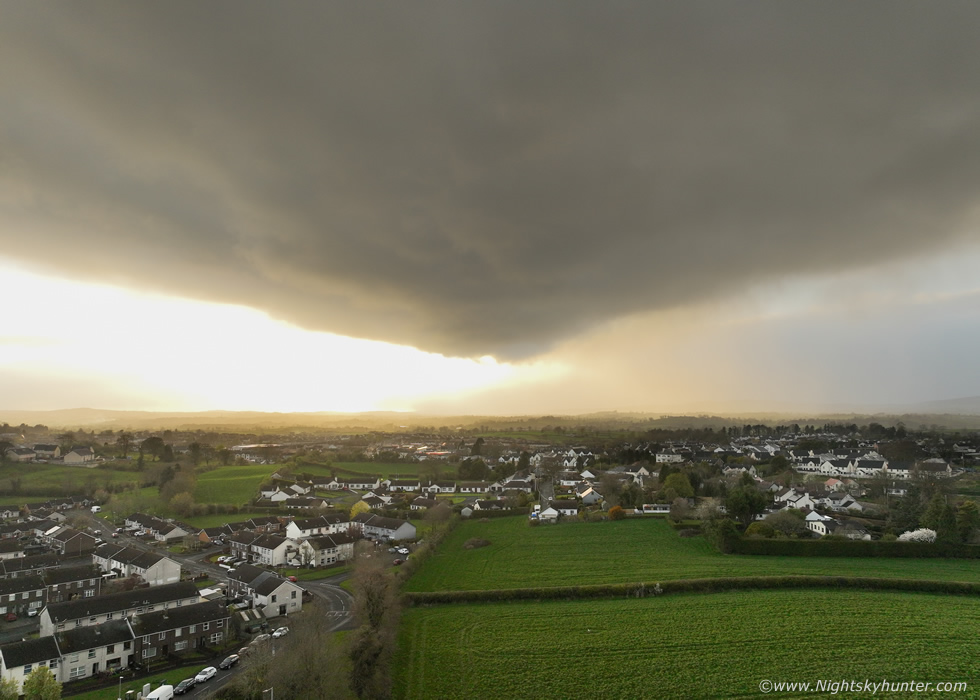
My favorite image of the ten or so I was able to rapidly shoot with the base over the edge of Cookstown with the cloud darkened slightly to better match the naked eye experience. The cell was back-lit by the sun and sunlit warm-coloured precip was falling behind and to the right side, a very high dynamic range scene. This is what's called a rain free updraught base, remember 40-60 knots of shear was influencing the cell rite now, exceptionally strong, this means the small tower was being tilted away from the base venting precip to the side so the base was momentarily dominating and exhibiting its full splendor as it tried to ingest any remaining unstable air (inflow). In Summer and in high CAPE versions of this the storm would be organized and severe with a chance of tornadoes. However this cell was using up limited instability, but that didn't matter, it looked amazing. I don't think I've ever captured a scene like this in early April before!, perhaps an omen of a great season to come.
 |
The sun was coming out more and base was almost over me with very obvious structure more likely observed on a strong Summer thunderstorm. I shot two short clips then the rain began to fall, you can see streaks of precip on the image above, then it was pouring, I raced the drone back 400m through heavy rain and landed, the drone was absolutely soaked. The cell moved E then died, it was short lived but very impressive. Colleen, John and I had been chatting earlier about how it seems the best scenes have been happening at home in recent weeks, and sure enough it happened again. I have to say I was well satisfied with these images and how I was caught off guard near the end of the day, it just goes to show how unpredictable nature can be. I noticed on the charts that the models were showing a notable storm set-up for Wednesday April 15th a full week away, I didn't pay it much heed at that range but as it turned out it made for an interesting chase day, that will be my next report. Thanks very much for reading!
Martin McKenna
